The Florence Effect on Logistics
By Stephen Bennett, Founder & Chief Operating Officer, Riskpulse
Published: September 15th, 2018
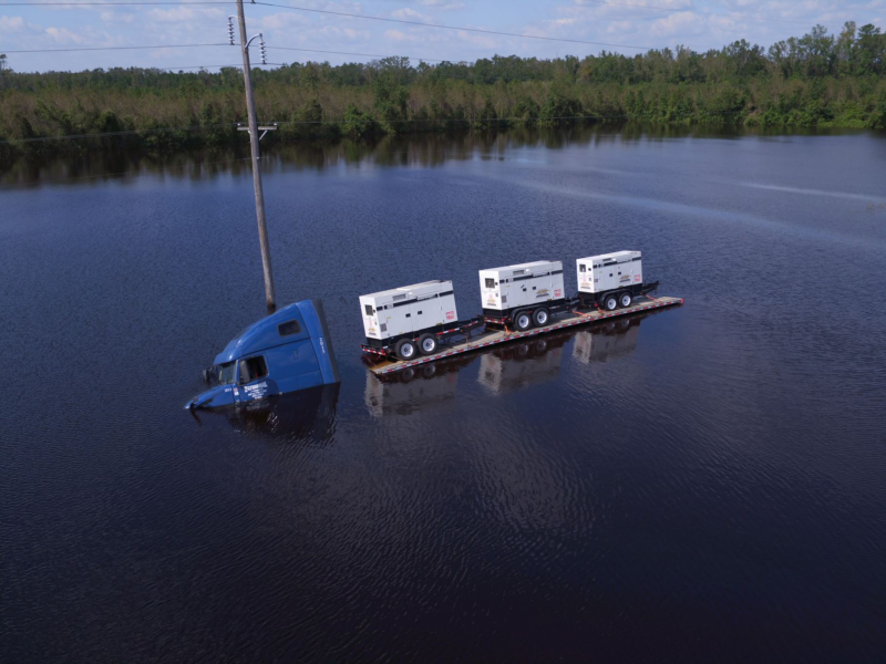
Thankfully, Florence didn’t live up to some of the early expectation that it would be the strongest storm to impact the East Coast in more than 25-years. Even so, with 105mph winds, it has been the most severe landfalling storm in Wilmington NC since Hurricane Helene in 1958 and it has had dramatic economic impact on corporate supply chains.
My team at Riskpulse serves shippers, carriers, and freight brokers providing prescriptive analytics integrated across their daily and intraday shipping plans.
Our customers plan for their demand well in advance of each storm stocking grocery shelves ahead of storms like Florence. For example, over 20% of the stores for one major Southeast grocery chain were stocked-ahead of Florence based on store-by-store demand analytics. We also work with beer brewers who are sending cans of water (in lieu of beer) into the storm zone.
Across our network of shipments, 25% of the truck-loads moving into Maryland, Delaware, Virginia, the Carolinas, and Georgia are disrupted and likely delayed. These trucks are hauling commodities such as beer and wine, milk and cheese, ice cream and other consumer goods. We’ve identified over 2,500 high-risk loads inside the storm representing nearly $100-million in total shipment value.
Predictive Analytics have entered a “golden age” where shippers, carriers, brokers and 3PL’s are increasingly taking a technology-empowered leadership position keeping the supply chain moving when it matters most.
The movement of disaster supplies will certainly impact freight capacity and freight rates in the weeks ahead.
There will be a disaster zone in the Carolinas primarily east of I-95 centered around Wilmington NC and Myrtle Beach SC. 869 retail locations in the Riskpulse Network are expected to be closed for days or weeks due to possible damage from the storm. These are banks, grocery stores, post offices, fast-food restaurants, and convenience stores.
Freight stopped transiting major interstate corridors such as I-40, I-95, I-74, I-85, I-77, I-26, and I-20. We expect that interstate highways will begin to reopen early next week and will not suffer lingering impacts.
The Ports of Norfolk, Charleston and Savannah have experienced operational disruption. The Port of Norfolk is a major hub handling 7,000 moves per day. A significant percentage of these moves were impacted on Thursday and Friday in advance of the storm but there was no damage. Norfolk will be operating at full capacity beginning Saturday but we it will take about a week to clear the backlog that’s built up over the past few days.
The Ports of Savannah and Charleston will remain closed for much of the weekend but there will not be significant damage and both should be operating again early next week. When the ports reopen, congestion will have to be cleared which will take about a week.
The highest impact for business closures will persist through Sunday. Freight will remain stopped. Outside of the disaster zone (i.e. outside of areas near Wilmington and Myrtle Beach), businesses should begin coming back online early next week and freight will begin flowing again.
Major impacts are also expected in the agriculture sector. Corn, soybeans, cotton, and tobacco within the Carolinas and fringe areas of Georgia are most impacted. Tropical storm force winds, tremendous rains and widespread flooding are the primary risks. Additionally, chicken and hog operations in the eastern Carolinas, especially southeastern North Carolina and northeastern South Carolina will be severely impacted.
- North Carolina is the second largest producer of hogs and pigs.
- Pork production in North Carolina has a total economic impact estimated at $9 billion,
- North Carolina is the 7th largest poultry producer
- North Carolina corn harvested is only 43%
- North Carolina cotton is 42% open boll. SC cotton is 28% open boll
Florence produced widespread power outages across southeast North Carolina and northeastern South Carolina. Outages will be long-lasting inside the disaster zone east of I-95 around Wilmington and Myrtle Beach. Elsewhere, power should return within a few days as the primary impacts from Florence move east.
Winds from Florence were clocked on-shore between 90mph and 105mph and a 7 foot storm surge measured at the US Coast Guard measuring station at Emerald Isle, North Carolina. The last major hurricane (category 3 or higher) in Wilmington was Hurricane Helene in 1958 with 135 mph winds. Since then, hurricane forecasting has radically improved. Over the past fifteen years alone, forecast errors have declined by about a factor of two. These improvements in the science of hurricane forecasting empower us to precisely and accurately assess the commercial disruption caused by these events. Predictive Analytics have entered a “golden age” where shippers, carriers, brokers and 3PL’s are increasingly taking a technology-empowered leadership position keeping the supply chain moving when it matters most.
Related post

What Is a Risk Management Plan?
The Need for a Supply Chain Risk Management Plan What a year 2020 was for supply chains. No wonder more companies are going beyond supply…

Using Supply Chain Predictive Analytics to Reduce Risk
Supply Chain Predictive Analytics and Customer Service Service. It’s the difference between an average company and one that stands out from the rest. Forbes reports…
How to Mitigate Risk in The Supply Chain
The Supply Chain Risk Management Assessment A Deloitte Touche Tohmatsu survey found that 85 percent of global supply chains experienced at least one disruption in…